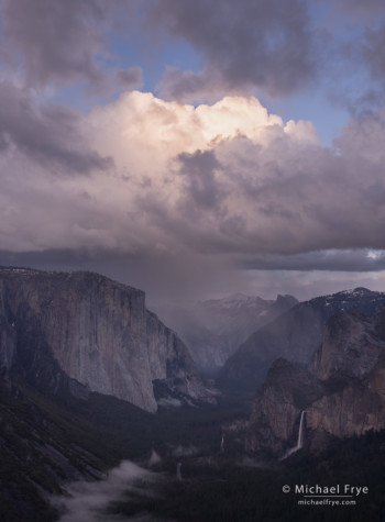
Rain squall over Yosemite Valley from near Old Inspiration Point, Yosemite
Photography encourages us to go to new places, and to be out during the most beautiful times of day when others are asleep or eating dinner. And sometimes – for me anyway – getting to those places can turn into a bit of an adventure.
Last April, on Easter Sunday, Claudia and climbed over 2,000 feet in elevation through rain squalls toward Yosemite’s Old Inspiration Point. We never actually made it there, but we found another good spot nearby, and had a great adventure, as described in my post A Harebrained Idea.
In August, the Rim Fire broke out west of Yosemite. The fire spread rapidly, expanding into Yosemite, and eventually becoming the third-largest fire recorded in California.
I knew this was a big event in the history of Yosemite, so I turned my attention to photographing the fire. During my first attempts I stayed close to the road, as I described in this post. But later Claudia and I made an epic bushwhack to a dome near the Tioga Road, where I captured a panorama of the fire at dusk, shown below.
In my original post about this day I actually didn’t go into much detail about the bushwhack. I’d visited this dome once before, many years ago, to photograph a shapely Jeffrey Pine visible from the road. I remembered it as being a tough hike – only about three miles, roundtrip, but with lots of brush, and clambering over rocks. Yet this seemed like the best place to get a view of the Rim Fire. We decided to go for it, hoping the trip wasn’t as bad as I remembered.
It turns out that my memory was pretty accurate. Going out to the dome wasn’t terribly difficult, though we were thrashing through brush, racing the to get there before the sun sank into the smoke. But finding our way back in the dark, trying to follow an intricate route that avoided the worst of the brush and rocks, was another story. We got off route twice, actually reaching the road half a mile from where we parked. It took us two hours to go a mile and a half, reaching our car at 11:30 p.m. But we made it back safely, with a story to tell, and I captured perhaps my best photograph of the fire from that dome:
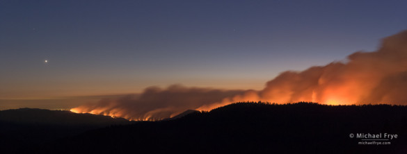
Looking west at the Rim Fire from near the Tioga Pass Rd. at dusk, with Venus setting, 8:57 p.m., 8/22/13, Yosemite NP, CA, USA
We made several other trips to photograph the fire – luckily with no more major adventures. On one of these trips I made an image of star trails over the fire. Firefighters gradually gained containment, the fire dwindled, and eventually all the major roads reopened. In my post After the Fire, I included a mini-portfolio of images made after other major fires in the Yosemite area, showing that life will go on, and beauty will return to the areas that burned.
— Michael Frye
Did you like this article? Click here to subscribe to this blog and get every new post delivered right to your inbox!
Michael Frye is a professional photographer specializing in landscapes and nature. He is the author or principal photographer of The Photographer’s Guide to Yosemite, Yosemite Meditations, Yosemite Meditations for Women, and Digital Landscape Photography: In the Footsteps of Ansel Adams and the Great Masters. He has also written three eBooks: Light & Land: Landscapes in the Digital Darkroom, Exposure for Outdoor Photography, and Landscapes in Lightroom 5: The Essential Step-by-Step Guide. Michael written numerous magazine articles on the art and technique of photography, and his images have been published in over thirty countries around the world. Michael has lived either in or near Yosemite National Park since 1983, currently residing just outside the park in Mariposa, California.


Loved this particular blog, Michael! Your ‘inspirations’ always inspire me to get off my butt and head out in my car and select a local day drive to YNP, or Kings Canyon, & Sequoia. I do enjoy trying different trails/roads than the out of area visitors and bus loads of tourists. Recently added Pinnacles NP to a couple of day trips…my, oh my! Such a diversity when compared to the eastern side NPs.
Wish I had your camera equipment, knowledge, skills, and visual creativity. Since I don’t, I’ll continue enjoying your submissions. 😉
Thank you Ann! I haven’t been to Pinnacles in a long time, but I should go back.
Time to consider a new visit to PNP (not in the summer!) Do you have photographs of gorgeous scenes in Sequoia and/or Kings Canyon NP? I particularly love Spring and Winter photographic views of The Great Western Divide.
Ann, I haven’t spent a lot of time in Sequoia and Kings Canyon, so I only have a few photographs from there, and none of the Great Western Divide.
I would love to see you make a trek to them one of these days! The panoramic Great Western Divide is breathtaking. These two parks, unfortunately, are often considered a step-child to YNP. Oh well, I love them, too, and the day drive is even closer to my home.