In the Moment:
Michael Frye's Landscape Photography Blog
by Michael Frye | Mar 17, 2014 | Yosemite Photo Conditions
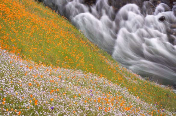
Wildflowers above the South Fork of the Merced River, March 25th, 2009
We’ve had an exceptionally dry winter, but a few well-timed storms in late February provided sufficient moisture for the poppies to start blooming in the Merced River Canyon, along Highway 140 west of Yosemite. I drove up the canyon on Wednesday and saw scattered patches of poppies. By yesterday afternoon the bloom had progressed considerably, with larger, denser swaths of orange on the hillsides.
The best poppy blooms in this area often follow dry winters. Wet winters create a thick, tall carpet of foothill grasses that crowd out the poppies, while drier conditions lead to sparser grasses and more room for poppies. The two best blooms I’ve seen, in 2009 and 2012, both occurred after below-average winter precipitation. It’s too early to tell whether this year will be that good, but the rapid spread of flowers within the last four days is a good sign. If things keep progressing the bloom could be spectacular by next weekend. Or not. I’ll keep you posted!
(more…)
by Michael Frye | Mar 3, 2014 | Yosemite Photo Conditions
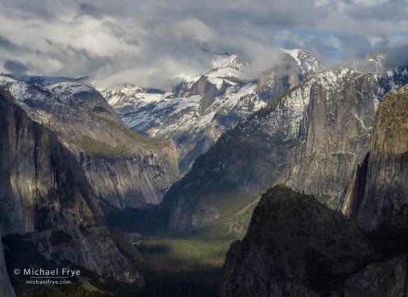
Dappled light on Half Dome and Yosemite Valley from near Old Inspiration Point, Saturday afternoon
Two storms unfolded almost exactly as forecasters predicted last week. On Wednesday night the first system dropped about 1.5 inches of rain on Yosemite Valley. The second storm on Friday dumped almost exactly two inches of rain. Badger Pass, 3,000 feet higher than the Valley, got about 18 inches of snow overall.
Despite these storms, rainfall totals are still only about 50% of average. In a normal year, Yosemite Valley would have received 26.9 inches of rain since last July 1st, however the current rainfall total for the season is only 12.9 inches.
(more…)
by Michael Frye | Feb 26, 2014 | Yosemite Photo Conditions
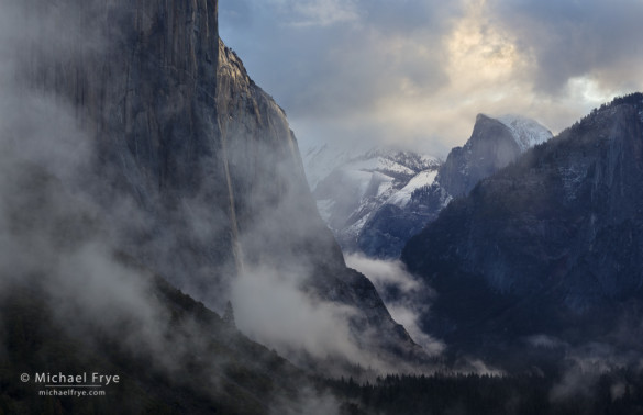
Clearing storm at sunrise, Tunnel View, Yosemite NP, CA, USA
In our extreme California drought, any potential precipitation is big news. This week two storms are forecast to reach the Sierra Nevada: one tonight, and another, stronger system on Friday, continuing into Saturday. While these are colder storms than the last ones, it doesn’t look like Yosemite Valley will get any snow. The snow level is expected to drop to 4,500 feet on Saturday night, just above the valley floor (at 4,000 feet), so it’s possible the valley could get an end-of-storm dusting if the snow-level predictions are a little off. But lower elevations should get a couple of inches of much-needed rain, and the high country could get over two feet of snow – a very welcome addition to the snowpack.
While the window of best light on Horsetail Fall has passed, any precipitation brings the potential for a photogenic clearing storm. Based on the forecast, it looks like we’ll see some clearing tomorrow, and again on Saturday or Sunday (or maybe both). We’re approaching the best time of year to photograph Tunnel View and Valley View (a.k.a. Gates of the Valley), because the late-afternoon light is balanced between El Capitan on the left and Cathedral Rocks on the right. If a storm clears late in the day that will create ideal conditions at both of those classic views. Of course I describe both of these spots, and many others, in The Photographer’s Guide to Yosemite, available as both a softcover book and iOS app.
(more…)
by Michael Frye | Feb 18, 2014 | Yosemite Photo Conditions
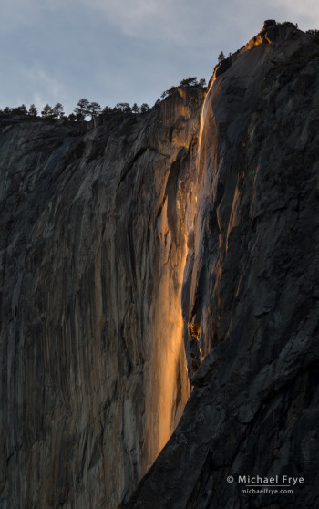
Horsetail Fall just before sunset, Sunday evening, 5:28 p.m.
Yosemite got some showers on Saturday night, which helped to add a little water to Horsetail and create a decent flow – below average, but probably better than anything I’ve seen the last two years.
Sunday evening a workshop student and I joined the throngs of photographers near the El Capitan picnic area. Some thin clouds muted the the light a bit, and then thicker clouds cut the light off entirely just before it would have reached its peak intensity and color, and before the cliff behind the fall was in complete shade. But Horsetail still put on a good show, as you can see from the accompanying photo, made at 5:28 p.m.
Unfortunately the little boost in water level from Saturday’s showers probably won’t last long, and a hoped-for storm tonight and tomorrow now looks like it will bring only a slight chance of showers. I think Horsetail will keep flowing for at least the next week, but the flow will probably be pretty meager. Still, it doesn’t take much. With a clear sunset even a little bit of water can turn into a strip of neon orange. I’d guess the water flow will be similar to 2012; you can see what that looked like in this post from that year.
It now looks like the rest of February is likely to be dry. We really need a miracle March!
— Michael Frye
Related Posts: Another Clearing Storm, and a Horsetail Fall Forecast; Quick Horsetail Update
(more…)
by Michael Frye | Feb 11, 2014 | Yosemite Photo Conditions
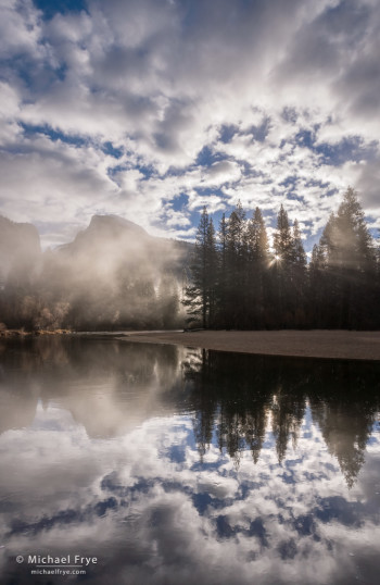
Misty sunrise, Half Dome, Merced River, and clouds, from yesterday morning
Northern California received some desperately-needed rain over the weekend. Most of that rain fell further north, so while Yosemite Valley got around 2.6 inches of rain, Blue Canyon, along Interstate 80 west of Lake Tahoe, got over 9 inches. But I’m not complaining. I’ll take whatever we can get, and those areas further north need the rain just as much as we do.
Like the last storm, this one also had a good sense of timing, clearing just before sunrise Monday morning. I rose early and photographed at several locations in Yosemite Valley, but my favorite image was this one of Half Dome from along the Merced River. I’ve posted other sunrise images from this spot before, but the cloud formations above Half Dome yesterday were exceptional.
The snow levels with this system were high, above 8,000 feet most of the time. I haven’t been able to find snow totals for Tuolumne Meadows, but Mammoth Mountain got two to three feet of snow, and Tuolumne probably got similar amounts.
The waterfalls in Yosemite Valley got a big boost from this storm. Their flow will diminish as the immediate runoff from the storm dissipates, but that new high-elevation snowpack will help feed the waterfalls for awhile, and we should see near-normal water flow for at least the next month or so.
(more…)


