Over the last couple of days Yosemite received a big dose of rain and higher-elevation snow. It was one of those “atmospheric river” events, with subtropical moisture streaming into the northern part of California. Usually when this happens satellite photos will show a direct, straight line of clouds extending from somewhere near Hawaii toward California. But this time the river took a detour, starting north of Hawaii, then bending up toward the Gulf of Alaska and back down to Northern California. This screen shot from the Upweather app at 2:00 p.m. yesterday shows that path:
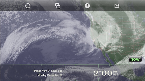
The atmospheric river aimed at northern California at 2:00 p.m. yesterday
Since Sunday afternoon Yosemite Valley has received over 5.5 inches of rain. We got over 3.5 inches at our house in Mariposa. That’s easily the biggest storm in this area since 2011, before the drought.
The snow level was around 7,000 feet, which meant that Yosemite Valley, at 4,000 feet, got rain instead of snow. Photographers would prefer snow, of course, but colder storms are never this wet, and this kind of storm was exactly what our drought-plagued state needed, dumping copious amounts of heavy, wet snow onto the Sierra high country. Badger Pass ski area, at 7,200 feet, got 18 inches or more of new snow. Mammoth Mountain, southeast of the park, reported two to three feet of new snow. I suspect that Tuolumne Meadows, at about 8,600 feet in the Yosemite high country, got even more. There was a dramatic rise in the snowbank visible from the Sentinel Dome webcam, at about 8,000 feet, as shown by these two images. The first was from Saturday afternoon, the second from this afternoon about 2:00 p.m.:
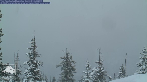
An image from the Sentinel Dome webcam on Saturday afternoon
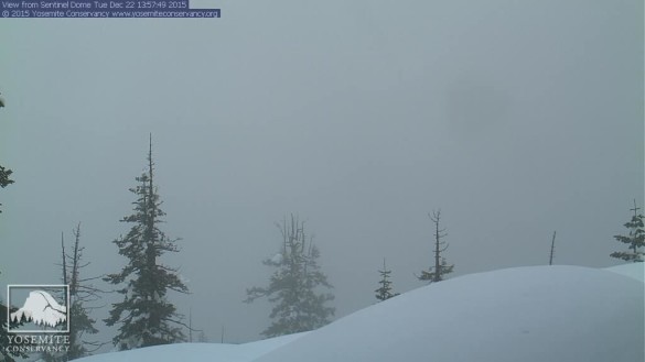
The Sentinel Dome webcam at about 2:00 p.m. this afternoon
No doubt there was some wind-aided drifting there, but still, that’s a lot of new snow!
The rain finally started to diminish this morning, though it looks like showers will continue for awhile. This storm brought the water-year precipitation total (measured from July 1st to June 30th) for Yosemite Valley to over 19 inches, which is a landmark, because it’s over half the annual average of 37 inches. It’s also more than the valley got for the entire 2014-2015 water year (a mere 16.16 inches). But we’re not there yet. I’ve seen many dry Januarys over the last decade, so let’s hope that we continue to get more rain and snow throughout the winter (though it would be nice of the storms are spread out enough to prevent flooding).
In the short term, a weaker but colder storm is expected to arrive on Christmas Eve, which might bring several inches of snow to Yosemite Valley, and even give us a dusting of snow here in the foothills. It could be a white Christmas!
— Michael Frye
Related Posts: A Snowy Morning; First Snowfall
Did you like this article? Click here to subscribe to this blog and get every new post delivered right to your inbox!
Michael Frye is a professional photographer specializing in landscapes and nature. He is the author or principal photographer of The Photographer’s Guide to Yosemite, Yosemite Meditations, Yosemite Meditations for Women, Yosemite Meditations for Adventurers, and Digital Landscape Photography: In the Footsteps of Ansel Adams and the Great Masters. He has also written three eBooks: Light & Land: Landscapes in the Digital Darkroom, Exposure for Outdoor Photography, and Landscapes in Lightroom: The Essential Step-by-Step Guide. Michael has written numerous magazine articles on the art and technique of photography, and his images have been published in over thirty countries around the world. Michael has lived either in or near Yosemite National Park since 1983, currently residing just outside the park in Mariposa, California.


That’s a great Christmas present for California. Let’s hope it keeps up. And, from a selfish standpoint, maybe some nice photo ops this winter. 🙂
Indeed, it is a great Christmas present. We’ve already had a bunch of storms and the clearing storms that go with that, so it’s been a great fall and early winter from that standpoint.
I’m praying hard for a wet winter!( complete with snow up there)
Thanks Deborah – we need all the help we can get!
I’m hoping we can send more rain your way! Up here in theNorthern Oregon coast range we had 14.5 ” in a week, and with this weeks rain I think it’s close to 18″ in the last 2 weeks. So good to hear about the rain for Yosemite.
That’s a lot of rain! But you certainly need it too.
Good news! Hope it keeps coming.
Indeed – thanks Robin.
JOLLY the Sierra high country! Thank you for your expert information, it makes me very happy – for everyone in California.
Thanks Sharon – makes me happy too. 🙂
Why did you name this photo as 122115-1400?
It may look like the date and time, but it’s actually a coded message to my Illuminati brethren. The new order is coming!
Or it may be the number my iPhone automatically assigned the image when I made the screen shot.
You can choose which to believe. The truth is out there.