In the Moment:
Michael Frye's Landscape Photography Blog
by Michael Frye | Feb 6, 2015 | Yosemite Photo Conditions
This photograph from 2009 shows what an average February flow in Horsetail Fall looks like
After a wet spell in December, the rain spigot got turned off. Yosemite Valley received seven one-hundredths of an inch of rain for the entire month of January. San Francisco set a record for January that can never be broken, with no measurable precipitation.
Not surprisingly, there isn’t much water in Horsetail Fall. In fact there’s no detectable flow at all – just a little dampness near the top. But forecasters are predicting a significant storm this weekend. They’re actually expecting two pulses, one tonight, and another on Sunday night. Total rainfall for the weekend could exceed four inches if the forecasts are right.
Horsetail should get a short-term boost from this storm. Whether that boost lasts longer depends on the exact snow level. Horsetail is fed by melting snow from a small drainage on top of El Capitan lying between 6,200 and 7,600 feet. The predictions for this storm put the snow level at 8,000 feet. If the actual snow levels are a little lower, and Horsetail’s tiny watershed gets some significant snow, then the runoff from that snow melting could last for a couple of weeks and provide at least some flow during the prime photography period later this month. If the snow levels are higher, and Horsetail’s drainage gets only rain, the water will run off quickly and won’t provide a lasting increase in the flow.
(more…)
by Michael Frye | Feb 18, 2014 | Yosemite Photo Conditions
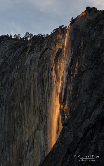
Horsetail Fall just before sunset, Sunday evening, 5:28 p.m.
Yosemite got some showers on Saturday night, which helped to add a little water to Horsetail and create a decent flow – below average, but probably better than anything I’ve seen the last two years.
Sunday evening a workshop student and I joined the throngs of photographers near the El Capitan picnic area. Some thin clouds muted the the light a bit, and then thicker clouds cut the light off entirely just before it would have reached its peak intensity and color, and before the cliff behind the fall was in complete shade. But Horsetail still put on a good show, as you can see from the accompanying photo, made at 5:28 p.m.
Unfortunately the little boost in water level from Saturday’s showers probably won’t last long, and a hoped-for storm tonight and tomorrow now looks like it will bring only a slight chance of showers. I think Horsetail will keep flowing for at least the next week, but the flow will probably be pretty meager. Still, it doesn’t take much. With a clear sunset even a little bit of water can turn into a strip of neon orange. I’d guess the water flow will be similar to 2012; you can see what that looked like in this post from that year.
It now looks like the rest of February is likely to be dry. We really need a miracle March!
— Michael Frye
Related Posts: Another Clearing Storm, and a Horsetail Fall Forecast; Quick Horsetail Update
(more…)
by Michael Frye | Jan 28, 2014 | Yosemite Photo Conditions
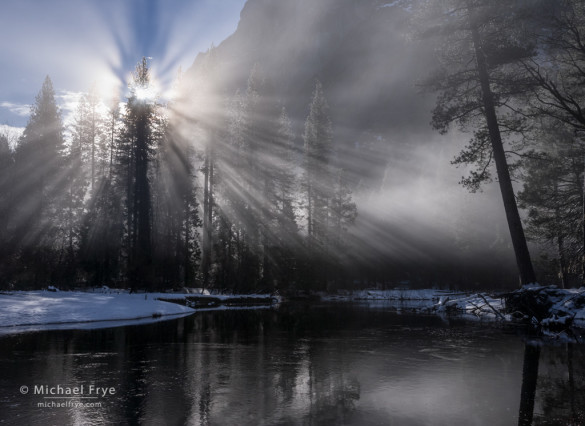
Sunbeams and mist along the Merced River, Yosemite
For many places in California, 2013 was the driest year on record. And so far this winter (our usual rainy season) has brought almost no precipitation. January has brought a procession of sunny days, with temperatures in the 60s or even low 70s at my house at 2700 feet in the Sierra foothills. It’s pleasant weather, but weird, and a little scary, as it seems like it will never rain again.
But finally the forecast is calling for rain and higher-elevation snow this week. It’s not supposed to be a big storm, but we’ll take what we can get. The main pulse of this system is due to arrive Thursday, but showers might linger into Friday or even Saturday. Snow levels are expected to stay at around 7,000 feet on Thursday, but may drop to 4,000 feet on Saturday, so it’s possible, though not likely, that Yosemite Valley could get a dusting of snow.
(more…)
by Michael Frye | Feb 22, 2013 | Yosemite Photo Conditions
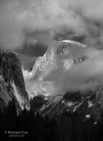
Half Dome and clouds, Yosemite NP, CA, USA
Many people, including me, had high hopes for the snowstorm that came through Yosemite on Tuesday. The forecast called for six to twelve inches of snow, so it sounded like we would see some beautiful snow scenes, and maybe even get to photograph a clearing storm. And some moisture might help revive Horsetail Fall.
Around sunset on Tuesday it started snowing at my house in Mariposa — first lightly, then heavily. In no time we had three or four inches of snow, and eventually got six inches, which is a lot for our 2700-foot elevation.
But the storm looked very compact on radar, and the precipitation didn’t seem to be reaching Yosemite. I called my friend Kirk Keeler, who lives in Yosemite Valley, and he told me that they had received only half an inch of snow.
Wednesday morning Claudia and I cleared the snow off our car and drove up to Yosemite Valley. We found an inch or two of snow — not a lot, but enough to highlight every tree branch. I saw many beautiful scenes with trees etched in snow, including the pattern of cottonwood branches below.
The morning was clear, but later some evaporation clouds started to appear, and they kept building. By the end of the day all the cliffs were hidden by clouds. But between 4:00 to 4:30 in the afternoon Half Dome and the clouds put on a great show. Half Dome would vanish completely, then reappear, wrapped in clouds and speckled with sunlight. I made the photograph above just before Half Dome disappeared for good.
(more…)
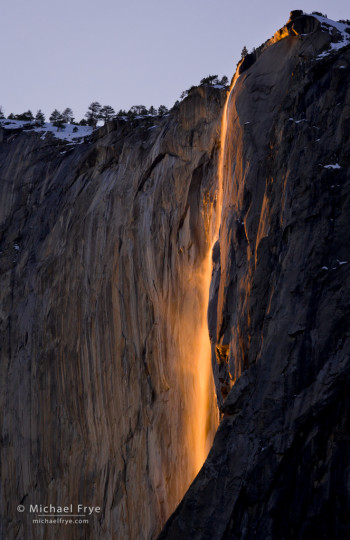
by Michael Frye | Feb 16, 2013 | Yosemite Photo Conditions
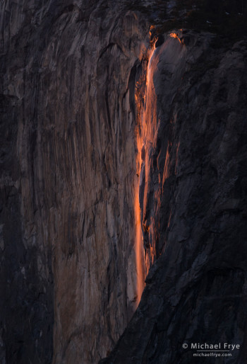
Horsetail Fall at 5:34 p.m. yesterday
It’s been quite dry in Yosemite since December, but there’s still some snow on top of El Capitan, and I thought that the warming weather over the last few days would melt some of that snow and increase the water flow in Horsetail Fall. But the flow is still disappointingly meager. I had a chance to photograph Horsetail last night, and I would say the water level is about the same as last year. The accompanying photograph was made from the Southside Drive area at about 5:30 p.m. yesterday. What water there is gets nicely highlighted when the light is just right, especially near the bottom of the fall, but… I wish the flow was better.
With low water like this I think the Southside Drive spot (Location 10 in my Photographer’s Guide to Yosemite book and iPhone app) works a little better than Rowell’s View near the El Capitan picnic area along Northside Drive (Location 1). From Southside Drive you’re a little further away, and you can see a bit more of the bottom of Horsetail Fall, which is the part that shows up best with conditions like this.
It’s supposed to be warm again today, so that might help increase the flow, but then temperatures are expected to trend downward tomorrow and Monday. On Tuesday forecasters are predicting the arrival of a snowstorm, which is expected to leave even colder air in its wake. The bad news is that the colder temperatures will slow down the flow in Horsetail Fall. The good news is that… a snowstorm is coming! And that, of course, brings the possibility of photographing snowy trees and cliffs, and maybe a clearing storm.
(more…)


