by Michael Frye | Aug 23, 2013 | Yosemite Photo Conditions
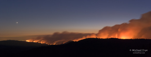
Looking west at the Rim Fire from near the Tioga Pass Rd. at dusk, with Venus setting, 8:57 p.m., 8/22/13, Yosemite NP, CA, USA
Last night my wife Claudia and I made an epic bushwhack to a dome near the Tioga Pass Road with a view of the Rim Fire. This is a two-image stitched panorama, looking west toward the Central Valley, with Venus setting on the left. Each frame was 30 seconds long.
This fire is growing at an alarming rate. It doubled in size yesterday, and as of this morning it was listed as over 105,000 acres. That already makes it the 19th-largest fire in California history. The Rim Fire crossed the western boundary of Yosemite National Park yesterday between Camp Mather and Eleanor Lake.
So far most of Yosemite hasn’t been affected. The smoke has been blowing north, away from the park. The biggest affect is the closure of Highway 120 outside the park, but there are alternate routes.
Let’s hope that growth slows down!
— Michael Frye
(more…)
by Michael Frye | Aug 22, 2013 | Yosemite Photo Conditions
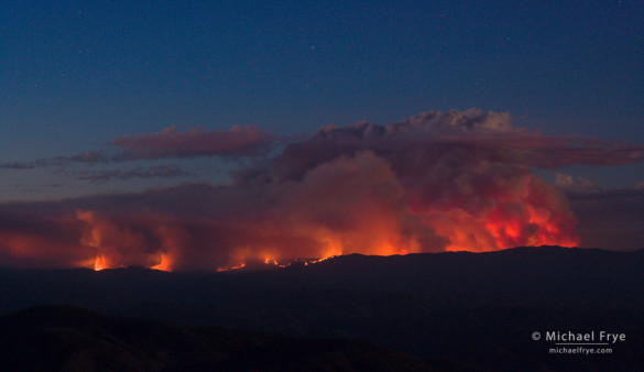
The Rim Fire at dusk, 8/21/13, from a viewpoint near Mariposa
Wildfires are common around here in summer and fall. Fire means smoke, and photographers visiting Yosemite during a fire sometimes complain about the smoke. I’ve learned to roll with it. When smoke spoils my plans, I make a new plan. That attitude actually applies to any photographic situation. I can’t control the weather, so I adapt to whatever conditions I find.
On Tuesday afternoon the clouds over the Sierra were spectacular, so Claudia and I headed up the Tioga Road to try to catch some of those clouds lighting up at sunset. As we approached Siesta Lake, however, we became immersed in smoke from the Rim Fire, and realized that the smoke would block the sunset light. So I went to Plan B, my standard plan in these situations, which is to photograph the fire itself.
(more…)
by Michael Frye | Jun 19, 2013 | Announcements
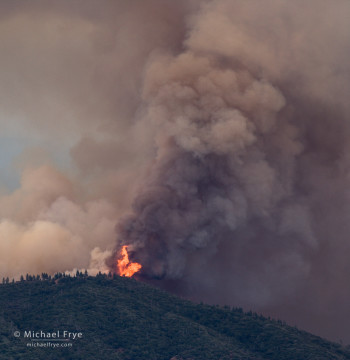
Flames on Buckingham Mountain during the Carstens Fire, Monday afternoon
We live in a fire-prone area, and we’ve had two dry years in a row. On Sunday afternoon a fire broke out about three miles from our house in Mariposa. Named the Carstens Fire, it started from a neglected campfire and quickly spread, pushed by winds and fueled by dry brush, grass, and timber.
I first heard about the fire when my wife Claudia called me on Sunday afternoon. She was in Fresno, and had received a call from a friend about the fire. I went outside, and from our driveway could see smoke to the north, so I got in my car and went on a reconnaissance. The good news was that the fire was about three miles away – close, but not an immediate threat. The bad news was that it was already a sizable fire, and the wind was blowing it towards our house.
We packed the essentials in case we were evacuated: computers, hard drives, important papers, valuables, mementos, clothes, supplies for our dog and cats. But the wind seemed to shift a bit, taking the smoke, and the fire, more to the east. We heard about evacuations in the Jerseydale area, about five miles to the northeast of us, but evacuation didn’t seem imminent for us. After sunset we went on another reconnaissance drive, and were mesmerized by the beautiful, eerie, orange glow behind ridges to our north.
(more…)


