Night Photography
by Michael Frye | Aug 23, 2015 | Night Photography, Workshops
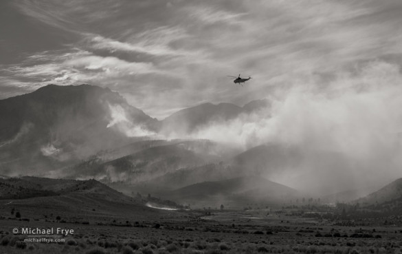
Helicopter over the Walker Fire from Highway 395, last Sunday evening
Our Starry Skies Adventure workshop turned out to be a little more adventurous than we thought. Just before we left our home in Mariposa last Saturday to head for the workshop I checked the satellite photos online. The Rough Fire near King’s Canyon National Park had been sending smoke north, so I was keeping an eye on it. But my last-minute check revealed a new smoke plume just to the southwest of Mono Lake. Uh oh. Our workshop was based in Lee Vining, on the west shore of Mono Lake, only a few miles from that smoke plume.
I could see the smoke from this new fire on one of the Yosemite webcams. I found that it was called the Walker Fire, and that it had started the night before near Walker Lake, but I couldn’t find any up-to-date information about the fire’s size and location. When Claudia and I left home about 3:00 p.m. the Tioga Road (Highway 120) through the park was still open. But when we got to Tuolumne Meadows we found that the fire had closed the road between the eastern entrance of the park and Highway 395. What do we do now? We decided we had to drive around over Sonora Pass and check out the fire in person. That meant five extra hours of driving, and a long night ahead of us.
(more…)
by Michael Frye | Aug 9, 2015 | Night Photography
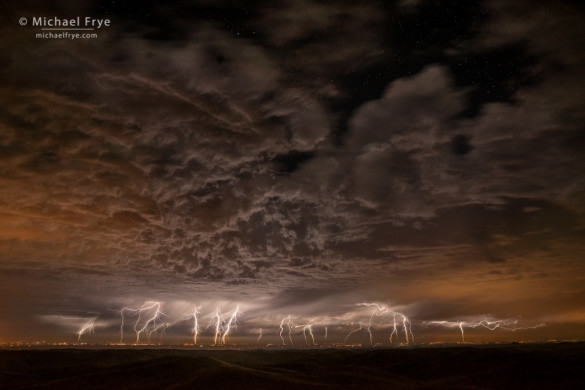
Lightning over the San Joaquin Valley from the Sierra Nevada foothills, California, USA
This summer I’ve often heard my fellow Californians making comments like, “Weird weather we’re having,” or “Interesting weather, isn’t it?” Yes indeed. Typically most of the state receives no precipitation from May through September, but this summer we’ve had lots of subtropical moisture drifting northward into the state, triggering showers and thunderstorms. The rains have mostly been light and scattered, so haven’t made any real dent in the drought, but have created interesting conditions for photography.
Last Thursday forecasters predicted another subtropical surge approaching, but we didn’t see much sign of it at our house. Then Claudia and I got into our hot tub around 10:30 p.m. (our nightly ritual before going to bed) and immediately noticed distant flashes of lightning. We couldn’t figure out where they were coming from at first; maybe the west? So I got out of the tub to check radar images, and saw that the nearest storms that could possibly be creating lightning were near the coast! That seemed impossibly far, but then last summer at Mono Lake, during our Starry Skies workshop, we saw distant flashes of lightning, and they turned out to be in eastern Nevada, 200 miles away. So yes, it was indeed possible to see flashes from lightning in the coast ranges, only 80 miles from our house.
(more…)
by Michael Frye | Jul 3, 2015 | Night Photography, Travels and Stories
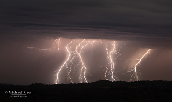
Lightning over the Sierra Nevada foothills, Mariposa County, CA, USA
We had some pre-Fourth-of-July fireworks here Wednesday night. At about 11:00 p.m. I let our dog Rider out before going to bed, and noticed flashes in the sky to the south. Sleep could wait! Claudia and I headed to a nearby viewpoint on Triangle Road, and saw lightning in three separate storm cells to the southeast, south, and southwest.
When watching thunderstorms you often only see cloud-to-cloud lightning, but on this night we could see some distinct bolts hitting the ground. I watched closely to try to determine where the most lightning activity was taking place. My first try didn’t work, but then another spot further to the right seemed to become more active, so I pointed my camera there, locked the tripod, and captured a series of 30-second exposures (each at f/9.5, 800 ISO). This photograph is a blend of five separate frames capturing seven or eight lightning bolts.
(more…)
by Michael Frye | May 10, 2015 | Night Photography
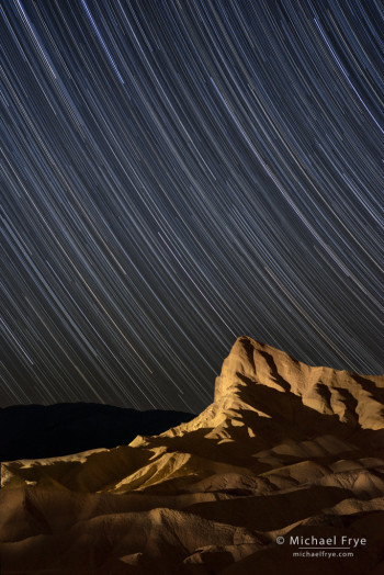
Manly Beacon at night with star trails, Death Valley NP, CA, USA
Manly Beacon is Death Valley’s most iconic feature, seen in millions of photographs from Zabriskie Point, including the image on the cover of the park map and brochure. So naturally I thought it would be fun to light it up at night.
One evening during our recent trip to Death Valley, Claudia and I, accompanied by our friend Robert Eckhardt, started down the Golden Canyon Trail from Zabriskie Point, carrying my powerful (3200 lumens), battery-powered spotlight, and radios for communication. Robert and I wanted a lower vantage point where the Beacon would poke up into the sky, and found a perfect spot. We set up our cameras and made some dusk exposures. Then after dark I hiked about half a mile further down the trail, carrying the spotlight and a radio, to a location I thought would work for the light-painting. Claudia acted as radio operator, and Robert tripped the shutters on both our cameras, while I used the spotlight to illuminate the Beacon.
We took a guess at the exposure, initially leaving the shutters open for 30 seconds at f/4, with the ISO set to 2500. According to Claudia and Robert’s radio reports, this exposure – surprisingly – turned out to be perfect. It did take several tries to get the lighting balance just right, but the problem was that the ridges underneath the Beacon weren’t getting lit from this spot. So I climbed back up the trail to a different location, closer to the cameras, which proved to be perfect for lighting those foreground ridges.
(more…)
by Michael Frye | May 3, 2015 | Night Photography
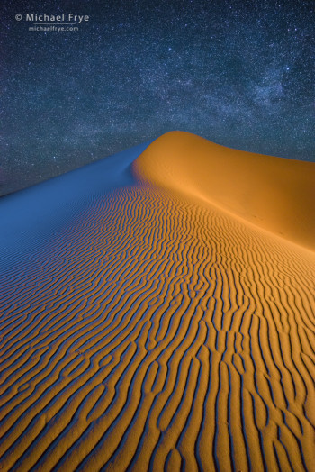
Sand dune and the Milky Way at night, Death Valley National Park
One night during our Death Valley workshop we went out to the sand dunes. After some searching, I found this wonderful dune with it’s rippled foreground textures. Lighting it was a group project; we all set up our cameras, and took turns lighting the dune from the left and the right, trying to find the right angles to highlight those ripples. Then we set our interval timers to record star trails – and took naps on the sand while we waited for the star-trail sequences to finish. After that the Milky Way was in the right position over the dune, so before moving our cameras we made some more exposures of pinpoint stars as well.
Recording all these exposures of the same composition gave us the option of including either star trails or pinpoint stars in the final image, and having the dune lit either from the left, the right, or both. I liked the pinpoint stars better, and chose to include lighting from both sides. The final image you see here is a composite of three exposures (assembled in Photoshop using the Lighten blending mode): one for the sky, one with the dune lit from the left (colored blue), and one with the dune lit from the right.
(more…)
by Michael Frye | Mar 31, 2015 | Night Photography
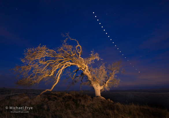
Oak tree and lunar eclipse sequence, Mariposa County, Sierra foothills, December 2011
Another total lunar eclipse will be visible in western North America this Saturday morning, April 4th. This is the third lunar eclipse in a sequence of four: we had two last year, and there will be another one on September 27th this year. But after that you won’t be able to see another total lunar eclipse in North America until 2018.
This upcoming eclipse will be brief; the total eclipse will last only five minutes! But for photography that’s enough. Here in California the eclipse will be visible in the west-southwest, about 18 degrees above the horizon, just before dawn. Since the moon will be low in the sky, you might be able to photograph it next to an interesting foreground object. You can find more details about this eclipse here.
For precise guidance about the moon’s position in relation to the landscape, I recommend consulting PhotoPills or The Photographer’s Ephemeris. Here’s the timing for the eclipse:
(more…)


