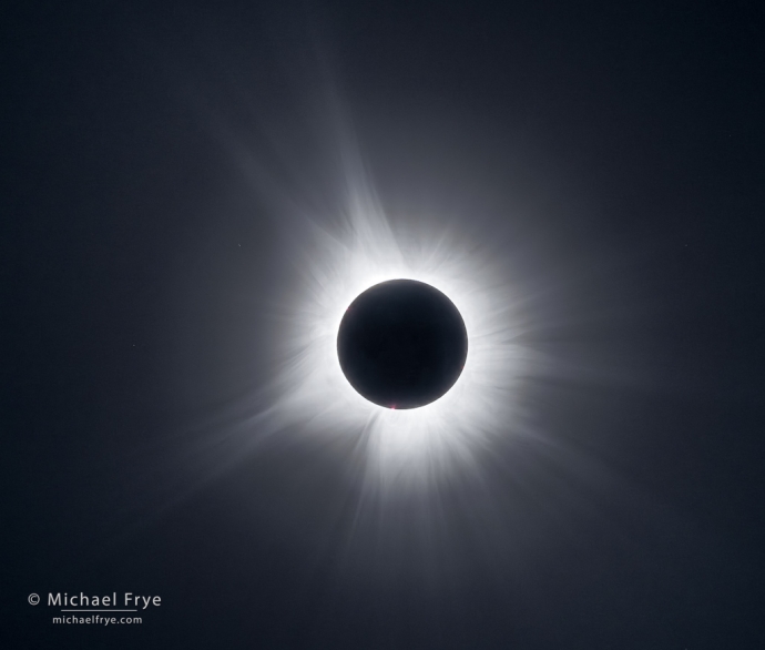
Total solar eclipse, April 8, 2024, northeast Arkansas
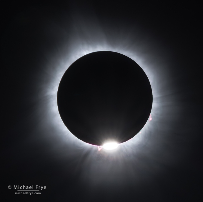
The “diamond ring” and solar flares as the sun emerges from a total solar eclipse, April 8, 2024, northeast Arkansas
I started thinking about the 2024 solar eclipse right after our last one in 2017. Claudia and I, along with our friend Robert Eckhardt, viewed that eclipse from the Sawtooth Mountains in Idaho, and it was such an amazing experience I immediately wanted to do it again.
When I looked at this 2024 eclipse, the best part was the length – four-and-a-half minutes of totality in Mexico and Texas, compared with only a little over two minutes in Idaho in 2017. Two minutes seemed way too short.
We didn’t make any reservations for this 2024 eclipse, as I wanted to stay flexible, and go where the weather looked most promising. We did get a very kind invitation from a friend of a friend to stay at his ranch in Texas on the eclipse path, so we started heading in that direction about a week before the eclipse, stopping along the way in the Mojave Desert, Arizona, and White Sands National Park in New Mexico.
By the time we got to White Sands the eclipse-day weather forecasts were looking rather iffy for Texas. All of Texas. Actually it looked like it could be cloudy along the whole path of the eclipse through North America, with a couple of small exceptions.
But some of the weather models showed a possible break in the clouds over Arkansas on eclipse day. We’d come all that way, and Arkansas was just a little farther than Texas, right?
We actually ended up in northeast Arkansas, about two-thirds of the way across the country from our home in California. We somehow managed to snag a last-minute camping reservation at Crowley’s Ridge State Park, in the path of totality (though near the southern edge), for the nights before and after the eclipse. (Someone must have cancelled.) That’s only a 90-minute drive from Memphis and the Mississippi River.
We arrived at our campsite Saturday night, and spent Sunday scouting possible viewing locations in the eclipse path. Meanwhile we learned that our friends Tim Aston and Dori Myer were also headed to Arkansas, so we invited them to camp with us. We ended up watching the eclipse together, and it was great to share the experience with friends.
By Monday morning, eclipse day, it looked like the worst-case weather for our area would be some high clouds, which could dim the eclipse, though not completely obscure it. But we hoped for no clouds.
We decided to head for Lake Charles. While not in the center of the eclipse path, it was close, and totality there would last 3 minutes 57 seconds. If we went to the center of the eclipse path in that part of Arkansas totality would 16 seconds longer, but at Lake Charles we could stand on the levee at the lake’s outlet, a slightly-elevated vantage point, and have a view of the 360-degree sunset during the eclipse – which was something we wanted to see.
We got there early – way earlier than we needed to, as it turned out, since the parking lot never filled. But better safe than sorry. We met a nice couple, Dustin and Grace, and helped Dustin carry his enormous telescope and tripod out onto the levee.
From that spot, the total eclipse was due to begin at 1:54 p.m. Around 9:00 and 10:00 a.m. some thicker high clouds moved overhead, but satellite photos showed they were likely to move past us by eclipse time. And luckily they did. By an hour before totality it seemed certain that we would have clear skies. Woohoo! After all we went through to try to see the eclipse, that was a great relief.
The whole experience from then on was amazing and wonderful. As the moon took increasingly bigger and bigger bites out of the sun, it got darker and darker – and cooler. Then we saw the diamond ring, the lights went out completely, and we could see the sun’s corona stretching impossibly far out from the eclipsed sun. What an incredible sight.
We got to look through Dustin’s telescope at a solar flare. We got to see the 360-degree sunset. Four minutes was still too short, but I think we got to experience the eclipse more thoroughly, more deeply, this time.
In 2017 I made a photograph that I like very much, but felt that I spent too much time during the eclipse fiddling with my camera, and not enough time taking in the view. This time I vowed to keep it simple. My previous experience allowed me to have everything set up in advance. I took a few bracketed sequences during totality, but that was it. The rest of the time I could just look.
The camera was still a distraction, but a minor one, and I’m glad I photographed the event. Although I just took closeup photographs with my 400mm lens, similar to images that other people made, there’s something about looking at your own photos of an event that triggers memories in a way that looking at other people’s photos can’t.
I hope many of you got to see the eclipse. The cloud forecasts for most of the eclipse path were pretty dire, but it seems that it wasn’t as cloudy as predicted in many places. That may not be a coincidence, as the cooling created by the eclipse would tend to dissipate clouds. We felt the temperature start to drop at least an hour before totality. I don’t think the weather models take that into account.
Anyway, seeing the eclipse was a wonderful, amazing experience – completely worth the long drive. I’m already thinking about the next one.
— Michael Frye
P.S. Just for fun, here are a few iPhone images from our journey to Arkansas.
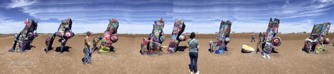
Distorted iPhone panorama of the Cadillac Ranch near Amarillo, Texas. Of course we had to stop at the Cadillac Ranch, since it’s right next to I-40. My last visit was in 1998, on an assignment for Texas Highways magazine. (You can find that photo on this page.)
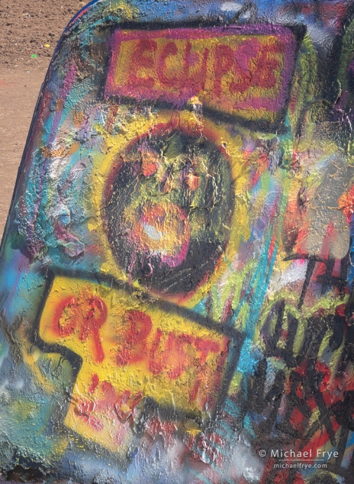
Spray-painted graffiti at the Cadillac Ranch near Amarillo, Texas. The property owners are now encouraging people to add their own artistic touches to the cars – they even sell cans of spray paint at the site.
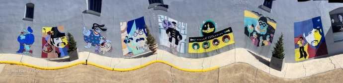
Distorted iPhone panorama of murals on Abbey Road, Walnut Ridge, Arkansas. In 1964 the Beatles made a brief stop in this town, changing planes at the airport. The town commemorated the event by naming a street “Abbey Road,” where you can find these Yellow-Submarine-themed murals, along with other Beatles artwork. To make this image I walked down the street past the murals during the exposure, tilting the phone to get the wavy effect.
Related Posts: Eclipse Journey; Winging It Through the Eclipse
Michael Frye is a professional photographer specializing in landscapes and nature. He lives near Yosemite National Park in California, but travels extensively to photograph natural landscapes in the American West and throughout the world.
Michael uses light, weather, and design to make photographs that capture the mood of the landscape, and convey the beauty, power, and mystery of nature. His work has received numerous awards, and appeared in publications around the world. He’s the author and/or principal photographer of several books, including Digital Landscape Photography: In the Footsteps of Ansel Adams and the Great Masters, and The Photographer’s Guide to Yosemite.
Michael loves to share his knowledge of photography through articles, books, workshops, online courses, and his blog. He’s taught over 200 workshops focused on landscape photography, night photography, digital image processing, and printing.


Great work on these photos of totality Michael. I ended up at the center of totality just north of Eagle Pass, Texas. Clouds were an issue there but cleared just in time for totality. But there was some haze around the eclipsed sun. Just glad I got to experience it. Four and a half minutes too! I also visited Cadillac Ranch a couple of weeks ago. Very interesting. Thanks for sharing your photos and story of your experience.
Thanks Ted! Glad to you got to see the eclipse. Things were looking pretty iffy in all of Texas, but luckily there were some breaks in the clouds.
It seems sad, a town celebrating the fact that the Beatles changed planes at the local airport in 1964.
Well I didn’t view it that way. The Beatles were a very, very big deal in 1964. Everything they did was news. And their “Abbey Road” was really fun – something that made you stop on the way through town. Clever bit of marketing actually, as it gets people to stop who otherwise would just drive right on by.
Fingers crossed for a composite . . . ?!
Sorry, no composite this time. Sun was too high in the sky to think about combining the eclipse with a landscape, I wasn’t interested in just an eclipse sequence by itself.
Great Pictures. We were in Jackson, Mo, just north of Missouri/Arkansas Border. Had great weather and a great time. We spent about 9 hours trying to get to Jackson and return to St. Louis, 100 miles. The eclipse was well worth the 9 hours in the car.
Wow, nine hours! Yikes! But I’m sure there were a lot of people in the St.Louis area going to see the eclipse.
I ended up in Uvalde, TX and most of the morning it looked like a total bust; thick clouds and rain. Luckily it thinned minutes before totality (sometimes I guess the cooling effect of an eclipse can dissipate storms) and we did get to see glimpses of the totality, and got serenaded by frogs and vultures during the darkness, but the obscuring from the high clouds meant we didn’t get a view of the corona. Remarkably, the pictures turned out to be magical. It’s a rare case where the pics outshined the in-person experience.
Thanks for sharing your story Larry. Glad you got to see some of the eclipse at least. There are instances where photos outshine (eclipse?) reality. I think annular eclipses are in that category. As an experience, a total solar eclipse is mind-blowing compared to an annular eclipse, but photos of an annular eclipse can be quite stunning.
Are your photos of the eclipse for sale?
Yes, of course! You can see the available print sizes and prices here:
https://www.michaelfrye.com/portfolios/print-ordering/
Just let me know which eclipse image you’re interested in, as I’ve made a few.