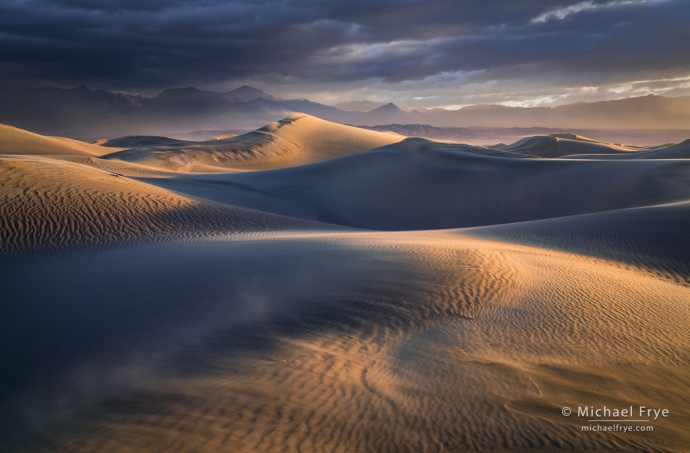
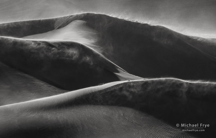
Dunes in a sandstorm at sunrise, Death Valley NP, California
Death Valley is a dynamic place. While the appearance of other landscapes frequently changes because of weather and seasonal changes, in Death Valley the land itself undergoes routine transformations caused by wind and water – especially the infrequent, but highly destructive, flash floods.
Last August Tropical Storm Hilary dumped over two inches of rain on Death Valley, washing out roads, closing the park for two months, and filling Badwater Basin with water – a resurrection of ancient Lake Manly. We visited Death Valley in late December, and got to see and photograph that lake, though it was shallower by then. (You can see some of my photos from that trip toward the bottom of my year-end-photos post.)
In late February Claudia and I headed back to Death Valley, where we met up with Jerry Dodrill before our workshop for Visionary Wild. In the meantime an atmospheric river in early February had refilled the lake, so it was much larger and deeper than in December. People were launching canoes and kayaks into the lake from the roadside just south of Badwater.
Then, just prior to our workshop, the wind started blowing. It blew hard from the south for three days, and into a fourth, and moved the entire lake at least a mile to the north. Here are satellite photos from February 27th, before the wind, and March 3rd, near the end of the windstorm:
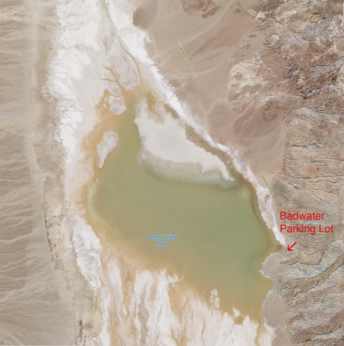
Lake Manly on February 27th, 2024, before the windstorm
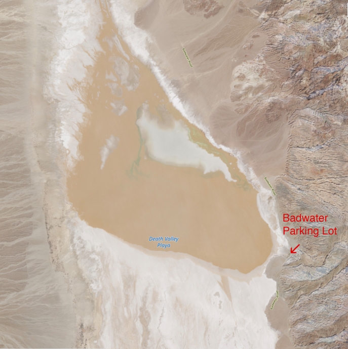
Lake Manly on March 3rd, 2024, during the windstorm, showing how far north the lake had moved. The water also turned a muddy red-brown color.
On March 2nd, during the windstorm, Jerry went down to Badwater and shot an amazing video of the muddy, red-brown water advancing south, against the wind, across the salt flats. By the next morning the lake had moved north again, but soon, as the wind died, it settled back to its pre-windstorm boundaries.
One morning during the windstorm Jerry and I headed out to the dunes. We saw a bank of dark clouds to the northeast, which I knew could provide a dramatic backdrop when the sun crested the mountains and lit the sand. The dunes, however, looked a bit odd: the southerly winds had scoured off the top layer of softer sand, exposing harder, wet sand underneath, and leaving rough-looking ridges instead of the usual smooth, curvy elegance.
So it was a struggle to find compositions I liked, but eventually I discovered a little swale with a great little curve in the foreground. When the sun hit this spot the raking light, blowing sand, and dark clouds created a dramatic scene – as you can see in the photograph at the top of this post. Most of my dune photos use telephoto lenses and focus on the patterns and designs of the dunes, so it was nice to have such great conditions for a wider view.
Later the winds shifted, blowing loose sand back over those harder ridges, restoring the dunes to their typical beauty. And the wind died down just before our workshop. We had a great time, with footprint-free dunes, flowers, and reflections in Lake Manly. We also found wonderful patterns in the salt flats, and dramatic light in the badlands. I’ve included a selection of Death Valley photos below from before and during the workshop.
Lake Manly is still around, though it will probably evaporate later this spring when it gets really hot. I’m glad we got to see it, as we may never see this much water there again in our lifetimes. But I’m sure wind and water will continue to alter Death Valley, and I look forward to seeing those changes.
— Michael Frye
P.S. Happy Easter!
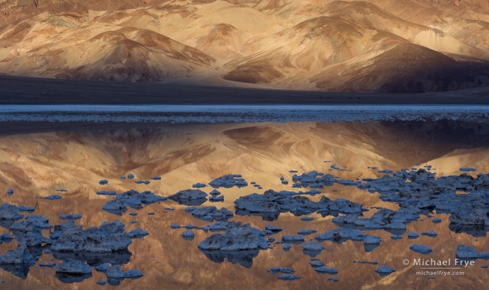
Badlands, reflections, and salt formations, Death Valley NP, California
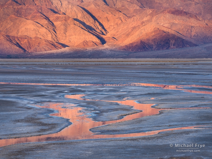
Mountains, salt flats, and stream rivulets, Death Valley NP, California
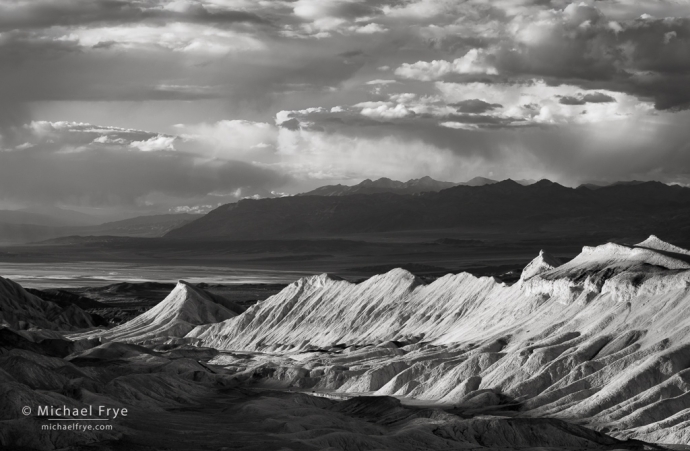
Badlands, clouds, and mountains, Death Valley NP, California
Wind-blown sand dunes, Death Valley NP, California
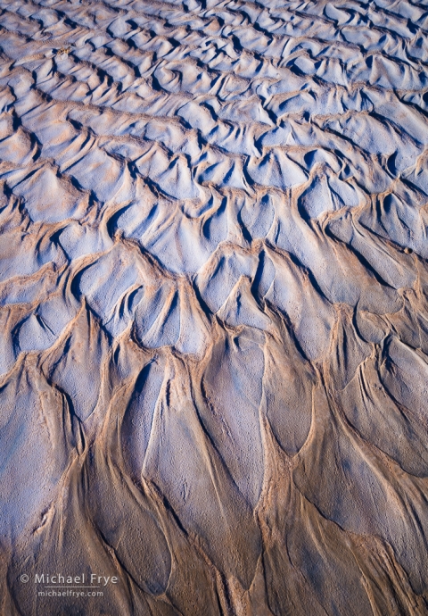
Mud designs, Death Valley NP, California
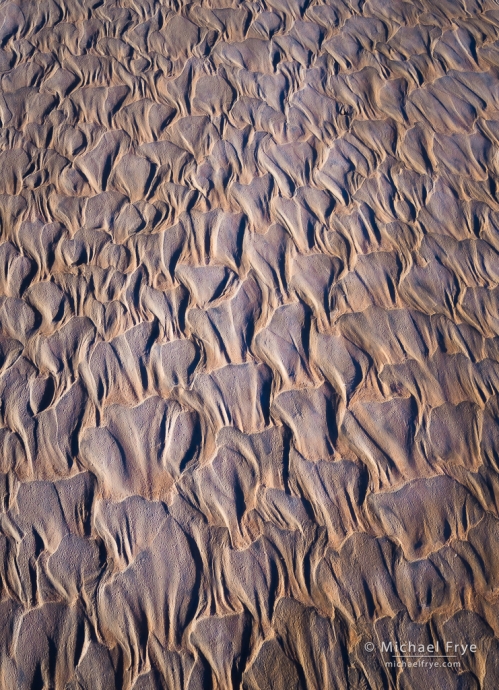
Mud patterns, Death Valley NP, California
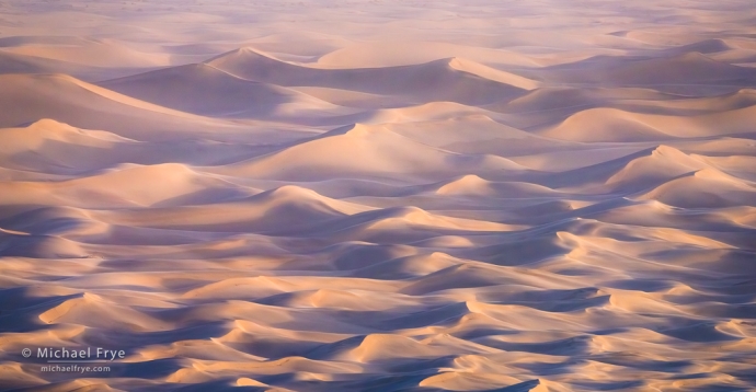
Dunes in a sandstorm, Death Valley NP, California
Related Posts: Death Valley; Wind, Dust, and Light in Death Valley; My Best Images of 2023: the Nominees
Michael Frye is a professional photographer specializing in landscapes and nature. He lives near Yosemite National Park in California, but travels extensively to photograph natural landscapes in the American West and throughout the world.
Michael uses light, weather, and design to make photographs that capture the mood of the landscape, and convey the beauty, power, and mystery of nature. His work has received numerous awards, and appeared in publications around the world. He’s the author and/or principal photographer of several books, including Digital Landscape Photography: In the Footsteps of Ansel Adams and the Great Masters, and The Photographer’s Guide to Yosemite.
Michael loves to share his knowledge of photography through articles, books, workshops, online courses, and his blog. He’s taught over 200 workshops focused on landscape photography, night photography, digital image processing, and printing.


Beautiful Images Michael. I managed to make a quick one day visit to Death Valley to see the lake in mid March. Like you say, this may be a site I will not see again in my lifetime.
Thanks Paul. Glad you got to see the lake!
I always am impressed at your vision, Michael. I was in DV a handful of days before you. On my first trip to DV (when I stopped, not just driving through), Lake Manly was there, but I didn’t realize it was a big deal, so I wanted to go back to photograph it. Thanks for posting the link to Jerry’s video — that was amazing! NPS said that Lake Manly moved 2 miles north.
Thanks very much Monika! The NPS says two miles, but I think that’s an overestimate. (They also haven’t acknowledged that the lake moved back to its original boundaries after the wind stopped.)
Gorgeous images, Michael! I love the beautiful patterns and colors the water and sand create—something I need to focus more on in my work! I hope you’re having a lovely spring—whenever it arrives! Take care.
Thanks very much Bob! Hope you have a great spring as well.
Spectacular images of Death Valley Michael! Looks like your on a different planet.
Thanks very much Randy! Death Valley does often resemble a different planet, which is no doubt why it’s been used as a filming location for many sci-fi movies.
Fantastic images! I hadn’t seen those satellite images before, that’s really neat.
It sounds like I arrived at just the wrong time this year – it got windy just as I arrived, and it died down as I left. Oh well! It certainly made for a few interesting images.
It was nice to run into you at Stovepipe Wells, too!
Thanks Brent! And it’s cool to see those satellite images, isn’t it? Great for things like that. As for your timing, I’d say it was perfect – wind and dust can be very photogenic in Death Valley. Nice to run into you too.