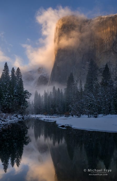
El Capitan and the Merced River at sunset yesterday evening
Several storms rolled through here last week. The largest of those dropped over two inches of rain in Yosemite Valley, and left a dusting of snow on the Valley floor Friday morning, but I couldn’t get up there early that day because Highway 140 was closed by mud and rock slides in the burn scar from the Ferguson Fire.
A smaller but colder storm was due to arrive Saturday, this time promising a chance for more significant snow. By noon Friday all the roads into the Valley had reopened, so I took a detailed look at the weather forecasts to see when this next storm might clear. Most of the information seemed to point to a clearing sometime after sunset on Saturday. But there was one item in the Hourly Weather Forecast on the National Weather Service website that hinted that the storm might clear before sunset. This graph showed sky cover (cloud cover) staying at 77% until 9:00 p.m., then dropping to 40% by 10:00 p.m. – well after dark. But the line showing precipitation potential dropped abruptly from 90% at 2:00 p.m. to 40% at 3:00 p.m. Hmm. Here’s what that looked like:
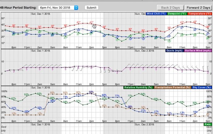
The hourly forecast from the National Weather Service for Yosemite Valley as it looked on Friday afternoon. Note the blue line for sky cover dipping between 9 and 10 p.m. on Saturday, but the brown line for precipitation potential dipping sharply between 2 and 3 p.m. (Click to view larger.)
A 40% chance of precipitation is pretty significant, and it still seemed likely that the storm would clear after sunset. And that might be fine, as I’ve photographed clearing storms at night before. Nevertheless, I would keep my eye on the radar and satellite images for signs that the storm would clear earlier.
On Saturday morning the webcams showed big, fat snowflakes falling in the Valley, and snow on the trees. By noon I could see the tail end of the showers approaching rapidly on the radar images. But that didn’t necessarily mean anything. At the end of a storm showers often linger in the Sierra long after sunshine reaches the Central Valley. But still, it could clear within a couple of hours.
I made myself lunch and started packing, but didn’t think there was any need to hurry. Yet at our house in Mariposa the rain had stopped and the sun was already breaking through the clouds as I pulled out of the driveway at 1:45 p.m. That happened quickly! I drove through some showers, but then saw patches of blue sky as I approached the park.
At Tunnel View skies were still mostly overcast, but I could see clear patches to the west, and some weak sunlight started to break through. I decided to head down to the valley floor, and by the time I reached this view along the Merced River the sun was hitting Half Dome, with blue skies overhead and mist below:
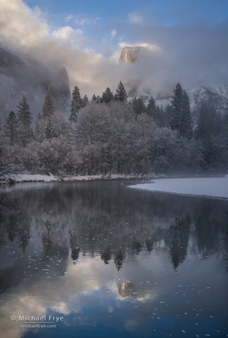
Half Dome and the Merced River yesterday afternoon
Soon the mist hid Half Dome. Should I stay and wait, or go somewhere else? I decided to move, hoping for backlit mist around El Capitan. That seemed like a good choice, as when I got my first view of El Cap it looked spectacular. I literally ran from my car down to the Merced River, set up my tripod, and got perhaps ten minutes of spectacular light before the mist congealed and hid everything. But ten minutes was enough to capture the scene at the top of this post.
After a long, dry autumn we’ve been treated to a series of storms recently, with a couple of well-timed clearings around sunrise or sunset. More precipitation is forecast for Wednesday and Thursday, though it’s expected to be too warm for snow in Yosemite Valley. In any case, I’ll be keeping an eye on the weather again this week, and throughout the winter. We need rain, and snow, so I’m hoping this is just the beginning of a wet winter.
— Michael Frye
Related Posts: Misty Morning in Yosemite Valley; A Clearing Storm by Starlight
Michael Frye is a professional photographer specializing in landscapes and nature. He is the author or principal photographer of The Photographer’s Guide to Yosemite, Yosemite Meditations, Yosemite Meditations for Women, Yosemite Meditations for Adventurers, and Digital Landscape Photography: In the Footsteps of Ansel Adams and the Great Masters. He has also written three eBooks: Light & Land: Landscapes in the Digital Darkroom, Exposure for Outdoor Photography, and Landscapes in Lightroom: The Essential Step-by-Step Guide. Michael has written numerous magazine articles on the art and technique of photography, and his images have been published in over thirty countries around the world. Michael has lived either in or near Yosemite National Park since 1983, currently residing just outside the park in Mariposa, California.


Those are beautiful Michael. I got lucky last year and have a very similar El Cap shot one morning after some overnight rain. I love how mother nature can add addition flavor to an already beautiful scene.
Thanks John, and I’m glad you were able to capture an El Cap photo that you’re happy with.
Outstanding post, Michael…thank you for the forecasting tutorial and beautiful images
Thanks Rob!
Man, I wish I lived somewhere with access to Yosemite. It’s such a beautiful place and one if the NPs I’ve not yet visited. You’re lucky to have been able to spend so much time in that gorgeous park. Keep upthe good work.
Thank, and be sure to visit Yosemite some time.
excellent work as always. I was in the valley the whole weekend and also got some nice photographs. But yours is always delightful to see. Thank you for posting
Thanks Gigi, and I’m glad you got some photos you like.
So enjoy having your photos as my screen saver from season to season. Grateful for your very fine work.
Thank you Jody!
What a great story and illustrations. I wish I could find the exact spot that I need in such a short time. You got it down to a science
Thanks Marek. It helps to know an area well.