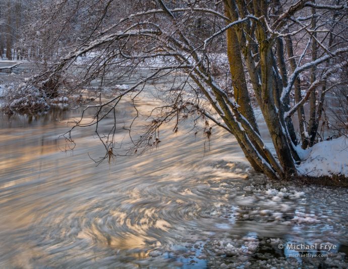
Frazil ice underneath alders along the Merced River, Yosemite, Friday morning. The shutter speed was 3 seconds.
As most of you probably heard, Yosemite got hit with some wild weather last week. The National Weather Service was predicting a major flood for the Merced River in Yosemite Valley on Sunday, January 8th. Their initial projection, issued on January 5th (I think) put the water level at Pohono Bridge at 23.7 feet, slightly higher than the 1997 flood, which closed the valley for two months. Then the next day the projection dropped to 15 feet, considered a moderate flood. On Saturday the projection climbed again to 16, 17, 18, then 19.7 feet – just below the “major flood” level of 20 feet. And then the projection dropped again to 15 feet, and then lower still.
Amid all these fluctuating river forecasts the park service preemptively closed Yosemite Valley to visitors on Friday at 5:00 p.m., and evacuated all non-essential employees on Saturday. They said they would reevaluate conditions by late Sunday or early Monday.
I had a workshop scheduled to start on Monday (January 9th) in Yosemite Valley with The Ansel Adams Gallery. Needless to say, the flood prediction and valley closure added a lot of uncertainty to that schedule. We initially pushed the start back to Tuesday, and then, when Aramark (the park concessioner) started cancelling everyone’s Tuesday night hotel reservations, we pushed it back to Wednesday.
As it turned out, the Merced River crested at 12.68 feet on Sunday night, barely above what’s considered the “moderate” flood level of 12.5 feet. The flood caused no major damage to infrastructure, and non-essential employees were allowed back into the valley Monday afternoon. The park service announced that the park would reopen to visitors on Tuesday, but with limited services. The hotels wouldn’t reopen until Wednesday.
And just to complicate matters, highways 120 and 140 were closed by rockslides on Monday. But 140 reopened around midday on Tuesday, allowing me to avoid a long detour, and providing a low-elevation route into the valley that didn’t require most vehicles to put on chains at that time.
Some of our workshop group couldn’t adapt to the change in schedule, but six adventurous souls made it to our Wednesday-morning meeting. And we ended up having great conditions. The water was high, as you might expect after a flood (even a relatively minor one). By the time I got to the valley on Tuesday afternoon the river was at 6.5 feet, well below flood stage, but still pretty full. All the meadows were partially flooded, and the waterfalls were at late-spring levels. The most impressive sight was Bear Creek, which parallels Highway 140 as it descends down the Briceburg grade. I stopped near the top of the grade and looked down into the creek, which descends over a series of small and normally-quiet waterfalls along that stretch. On that day I watched tons of deep brown water thundering down the cascades, throwing off plumes of spray.
It snowed on Tuesday in Yosemite Valley, then turned to rain on Wednesday, and back to snow on Thursday. We had some clearing-storm conditions Wednesday morning, and a moonlit clearing storm on Thursday evening. Thursday’s snow stuck to the trees for an unusually long time in shady areas, and we found mist along the river and meadows on Friday and Saturday evenings. All in all it was a great five days, which made all the scheduling uncertainty worthwhile.
Here are a few photographs from last week. We’ve got more weather on the way this week, with snow expected in Yosemite Valley tomorrow, and again on Sunday and Monday. Let’s hope there are no floods or rockslides this time!
— Michael Frye
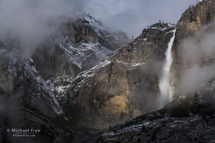
Upper Yosemite Fall during a clearing storm, Wednesday morning
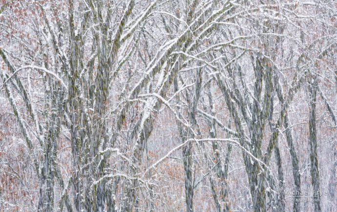
Black oaks in a snowstorm, Thursday afternoon. I used a shutter speed of 1/15th of a second to turn the falling snowflakes into short streaks.
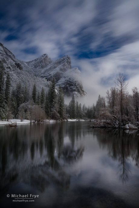
Three Brothers and the Merced River by moonlight, Thursday evening. The exposure was 20 seconds at f/4, 1600 ISO.
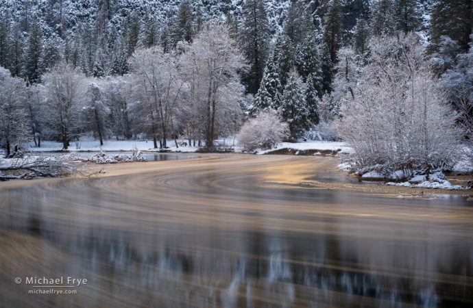
Reflections in the Merced River, Friday morning. The streaks were created by frazil ice floating down the river, with a shutter speed of 10 seconds.
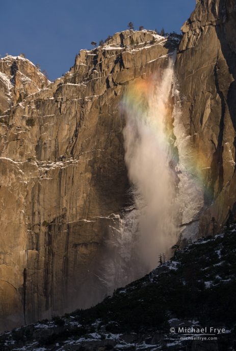
Rainbow on Upper Yosemite Fall, Saturday morning
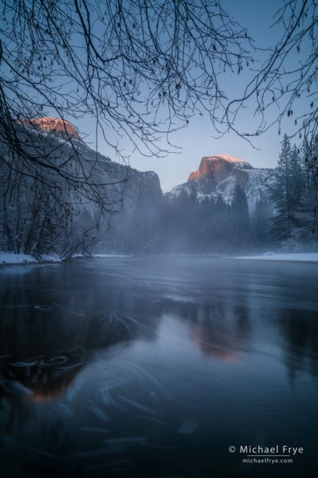
Half Dome, North Dome and the Merced River at sunset, Saturday evening. This was another slow shutter speed (4 seconds) to smooth the water and blur the foam into streaks.
Related Posts: Moonrise from Valley View; High Water in December
Michael Frye is a professional photographer specializing in landscapes and nature. He is the author or principal photographer of The Photographer’s Guide to Yosemite, Yosemite Meditations, Yosemite Meditations for Women, Yosemite Meditations for Adventurers, and Digital Landscape Photography: In the Footsteps of Ansel Adams and the Great Masters. He has also written three eBooks: Light & Land: Landscapes in the Digital Darkroom, Exposure for Outdoor Photography, and Landscapes in Lightroom: The Essential Step-by-Step Guide. Michael has written numerous magazine articles on the art and technique of photography, and his images have been published in over thirty countries around the world. Michael has lived either in or near Yosemite National Park since 1983, currently residing just outside the park in Mariposa, California.


Hi Michael,
Great pictures. I really like the one with the swirling light in the river bend.
We were up there this weekend, and were nervously watching the rockfalls come and go during the week, but it all worked out.
It was unfortunately mostly clear skies then, but we chased snow fog and the interesting lighting options that provided. We had some serious luck on El Capitan meadow on Sunday. A bit reminiscent of what we ran into during our private.
Thanks Doug, and I’m glad you had a good time in the park. El Cap meadow can be a great place.
What an exciting time for you and your group to be in Yosemite. I sat home wishing I could be either in Yosemite or the Columbia Gorge in Oregon. Alas, my presence was required at home.
Your images are amazing as always. Thanks for sharing. I love them all, but my favorite is also the river bend with the frail ice.
Thanks Gail – sorry you weren’t able to get up to the park.
Love the swirling light at the river’s bend as well. They are all lovely!
Thanks Laura!
Simply stunning. Awesome place to visit. If you can go there and see for yourself.
Thanks Bob!
Could you please tell me if you are using filters for these stunning winter scenes and if yes, which ones.I have been learning and shooting (on a serious level)for about a year and use a Canon 7D. With little time available, I shoot in the ponds, spillovers, creeks and trails here in New England, all year long. My favorite is winter.Before I invest in excellent filters I need more practical input. My photos and cards are well received & I love my work. Also do you find a larger external screen useful to preview your shot?
Debby, the only filters I used were neutral-density filters to allow me to use a slow shutter speed on some of the water images. I also sometime use a polarizing filter. No, I’ve never used a larger screen in the field like a laptop or tablet – too cumbersome.
Thank you.
Another wonderful set! BRAVO!!
Thanks Chuck!
Wonderful photos. What an inspiration to get my camera out and play around with it a bit. Thanks, Michael. And thanks for the shutter speed, etc., footnotes. A great resource.
Thank you Julian!
Great pictures and words. Love the shadow cast by Yosemite Falls.
Thanks Tarik – I appreciate it!
These photos are stunning but especially so as my friends and I camped there just this Fall… and it was a very different world.
I sat in the middle of mirror lake on a parched piece of wood.
Your photos lush with moisture, passion and the fluid movement of life are exhilarating!
Thank you for being there and capturing it!
Namaste Sea
Hi Michael,
As always, fantastic photographs! And thanks most kindly for the magnificent and rewarding experience!
Take care,
Cheers,
Alyn
Thanks Alyn, and I’m glad you were able to stick it out!
It was an outstanding workshop! I learned so much! Michael is an excellent teacher, and I so appreciate the opportunity to learn from him. I hope to be able to attend another of his workshops in the future – highly, highly recommend!
Thanks Elena – it was great having you with us!
Michael,
The beautiful, seasonal changes in Yosemite National Park are so remarkable that I often gasp when I see what you have captured in your photos. Nothing is ever the same at my favorite NP. Someday, I would love to see you photograph the gems of Glacier National Park. 😉 Thanks for continuing to gift us with your talents.
Thank you Ann! If I’m able to make good photographs of Yosemite, part of the reason is that I know the area so well, and spend a lot of time there. I wouldn’t expect to go someplace I barely know, like Glacier NP, for a brief time, and expect to come home with great images. But Glacier is a beautiful place, and I’d love to go back, regardless of whether I make any good photographs there.
Very nice, especially the Merced River reflections. Crazy weather there again this weekend! I’m curious whether you ever venture up higher (Badger Pass to Glacier Point area) in the winter? Always inspiring, thanks for sharing.
Thanks Josh. I don’t go up to Badger Pass often in winter. It’s mostly forested, so not that scenic by Yosemite standards, but there are things to photograph there. I’d love to get to Glacier Point in winter, but reaching it requires a 10-mile ski (one way), and it would be especially challenging breaking trail after a storm, which is the time I’d want to be there. One of these days I’ll get out there.
You might also consider Dewey Point. It can be a challenging ski once you’re off the road but it’d be very manageable on snowshoes (I’ve skied it once right after a storm). It gets enough traffic that the track is reasonably well-packed most of the time. I’ve tried to reach Sentinel Dome but the snow was about thigh deep from Glacier Point Road. I think the biggest challenge might actually be timing it when Badger Pass road is open! Thanks again.
Thanks for the suggestion Josh. I’ve been to Dewey Point a few times on skis, and once by foot in summer, so I’m pretty familiar with the route. It’s a great spot to go to, perched high above the valley. But I’m not as excited about the photography esthetics from there. It’s kind of an awkward view from a compositional standpoint, because you can’t see Bridalveil, and Cathedral Rocks are right below you, blocking a lot of the valley floor. I think Stanford Point works much better photographically, but it’s harder to get to in winter.
I guess I know where I’m going for my next winter Yosemite trip! That’s close enough to Badger Pass that the trail-breaking will come when legs are fresh too. Thanks for the idea, very much appreciated.
You’re welcome Josh, and good luck. There’s no marked ski trail to Stanford Point, so route-finding and navigation might be difficult – not to mention trail-breaking.
These are some awesome photos of Yosemite! I especially love that first one.
Thank you Danny!
Kicking myself for not getting up earlier that Thursday night. I checked the sky at 9 PM and it was still cloudy so I set my alarm for 1:30 AM, but by the time I stuck my head out of my room at the lodge, the sky was completely clear! That storm must have blown out in record time. Earlier that night the lodge looked almost deserted as there were just a handful of us eating when I returned from shooting. The recent flood provided some great opportunities with huge pools of water spilling over the roadways and meadows. I had a great time shooting reflections at Ahwahnee Meadow and Cook’s Meadow as well as several other spots on the North side. The only bummer was that the water level in the Merced was so high that it was hard to get any kind of a reflection at the valley view (Gates of the Valley) due to the fast water flow and the boulders which are usually capped with snow were completely submerged. I continue to use your app almost every time I am in the park. I hope to run into you one of these days while I am up there!
Well I hate to tell you this, but the storm actually cleared shortly after sunset on that Thursday. After sunset we went to the Food Court for dinner, and when we came out we saw the moon rising near Half Dome. The photo here of Three Brothers was made at 9:03 p.m.
Gah! That’s right when I stuck my head out the door. I was seriously sleep deprived at that point, and I could see that the moon was lighting up the sky, but the lodge was still underneath that cloud ceiling, so I assumed the valley was still socked in. I thought I would just sleep for a couple of hours and then the sky would begin to clear.
That settles it. No more sleeping when I’m in Yosemite. Glad your shots came out so well and that your group was successful. Your workshop students definitely got their money’s worth and more. 🙂
Hi Michael
I’m an artist and wanted to ask you if I could pay you to o use one of your images in my work? I believe I would need a release and wouldn’t want to infringe on any copyright. I’ll wait to hear from you
Graceschlesier.com
I will send you an answer via email.
Michael great work. I am not able to get to the park since I turned 80 last November.Thank you for keeping us informed thru your wonderful photos. Rich Conness.
Thanks Rich! It’s too bad that you can’t get to the park, but I hope that situation changes.
Hi Michael,
Love your work. Reading your “Photographer’s Guide…” right now before this weekend’s trip to the valley.
Looking at the weather, I doubt we’ll get to see the Firefall. But I’m looking forward to the winter landscape.
Would you mind sharing the locations from where you shot the last photograph above, the Half Dome by sunset, as well as the “Reflections on Merced…” ?
Thanks Abhijit. The Half Dome spot it described in The Photographer’s Guide to Yosemite under location 12. The Reflections in the Merced image is near Chapel Meadow.