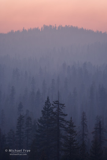
Pastel-colored smoke from the Rim Fire at sunset, 8/26/13, Yosemite NP, CA, USA
I’ve been spending every spare moment photographing the Rim Fire, but I’ve finally had a chance to process some images. I made this photograph Monday evening, as smoke spilled over from the Tuolumne watershed into the Merced watershed near Yosemite Creek, creating a layered view of pastel-colored trees.
The Rim Fire has become the largest fire in the recorded history of the Sierra Nevada, though undoubtedly much larger fires regularly swept through these mountains before Europeans arrived here. At 192,737 acres, the Rim Fire is also the sixth largest in California history, and seems almost certain to pass the Witch Fire (197,990 acres) for fifth place.
The fire’s growth has slowed considerably. Estimated containment for the Rim Fire is 30%, which represents a lot of progress for firefighters within the last few days.
Highway 120 west of Yosemite remains closed indefinitely. Within the park, Highway 120 is temporarily closed from the park’s western boundary to Yosemite Creek. This means that you can’t drive from Yosemite Valley over Tioga Pass to Lee Vining and Mono Lake (or vice versa). You can reach Tuolumne Meadows, Tenaya Lake, etc., by taking another route to Lee Vining, and driving into the park over Tioga Pass, but you’ll have to turn around at Yosemite Creek and leave the park via the same route.
The Tioga Road was closed to allow fire crews to perform burning operations between the road and Hetch Hetchy in an attempt to stop the spread of the fire to the east. The burn was actually scheduled for yesterday, but weather conditions apparently weren’t favorable. There’s no word on when the road might reopen.
If you haven’t seen this already, here’s an amazing video made from the cockpit of an air tanker dropping fire retardant along the edge of the fire. The video really shows the size and intensity of the fire, as well as the skill of the pilots. The video was made on August 22nd along the fire’s eastern front near Camp Mather and Hetch Hetchy. In fact the pilots drop their retardant right on Camp Mather, home of the Strawberry Music Festival; you can see Birch Lake just beyond their drop zone as they pull away. This coincides with stories I’ve heard that the buildings at Camp Mather were saved by air tankers dropping fire retardant.
Here’s a link to the official information page about the fire, and another link to information about the fire within Yosemite. And here’s one more link to a webcam with a view of the fire from the Crane Flat Lookout (second image down, and the camera is now actually pointed northeast, not northwest as it says). Further down that page you can see the Yosemite Valley webcams, usually showing remarkably clear skies.
And finally, don’t miss this exceptional time-lapse video of the fire, mostly made from that same Crane Flat Lookout, by Jonathan Byers and the National Park Service.
— Michael Frye
Michael Frye is a professional photographer specializing in landscapes and nature. He is the author or principal photographer of The Photographer’s Guide to Yosemite, Yosemite Meditations, Yosemite Meditations for Women, and Digital Landscape Photography: In the Footsteps of Ansel Adams and the Great Masters. He has also written three eBooks: Light & Land: Landscapes in the Digital Darkroom, Exposure for Outdoor Photography, and Landscapes in Lightroom 5: The Essential Step-by-Step Guide. Michael written numerous magazine articles on the art and technique of photography, and his images have been published in over thirty countries around the world. Michael has lived either in or near Yosemite National Park since 1983, currently residing just outside the park in Mariposa, California.
Did you like this article? Click here to subscribe to this blog and get every new post delivered right to your inbox!


Thanx for all the information, Michael. You are a blessing to those of us who live many miles away…
Thanks Patti!
Thanks so much for posting this information along with your great photos which I always enjoy. Will you go to my new Facebook page Yosemite Travel Tips and Insider Information for Mariposa County?
You’re welcome Meredy, and sure.
Thanks Michael. keeping an eye on it and hoping for the best.
We’re all hoping for the best Aram, thanks.
Thank you Michael for all the references. Incredible pictures & videos. I’ve been close to a wild fire/forest fire. Many have no idea just how dangerous it can be. A good friend spent his whole career with the Oregon Forestry Dept. He is now retired but fought some nasty ones before he was directing efforts to stop them.
You’re welcome Donna!
Hi Michael,
I’m a big fan of your work, always enjoy getting emails of your fantastic images. I will actually be coming to Yosemite on the 11th of September so hopefully things haven’t got any worse by then. Do you know if the fire has had any effect on the valley as we are staying at Curry Village? I’ve no doubt that the fire crews will be doing great work to contain the fire and hopefully everybody stays safe. I guess that’s one of the drawbacks of living where you live although I bet you wouldn’t trade those views for anything right? Stay safe and best wishes.
Dan
Thanks Dan. So far the fire has had almost no effect on Yosemite Valley. There was a little smoke in the valley a few days ago, but mostly it’s been smoke-free. I don’t really consider fire to be a drawback of where I live — it’s just part of life here.
Hi Michael,
You know every nook and cranny of Yosemite and beyond! Thank you for the information and links, I bookmarked and forwarded the air tanker video to all the people who were concerned, it was the most descriptive.
You’re welcome Sharon, and thanks!
Michael, do you know if the Crane Flat cam is out? Hasn’t updated since Aug 29 at 14:56. http://ssgic.cr.usgs.gov/dashboards/WebCam.htm
Sorry Sylvia, I don’t know what’s going on with that. I noticed it too.
Michael, I have been thinking of you ever since the Rim Fire broke out and hoping you were out of harm’s way. It was reassuring to read the information posted on your website and I thank you for that. The photo of the pastel-colored smoke at sunset on August 26 is stunning. There is beauty even in such a tragic event, and you have captured it masterfully.
Thanks for your kind words and good wishes John. I can’t really do anything about the fire one way or another, but it does create some great photo opportunities.