by Michael Frye | Mar 3, 2014 | Yosemite Photo Conditions
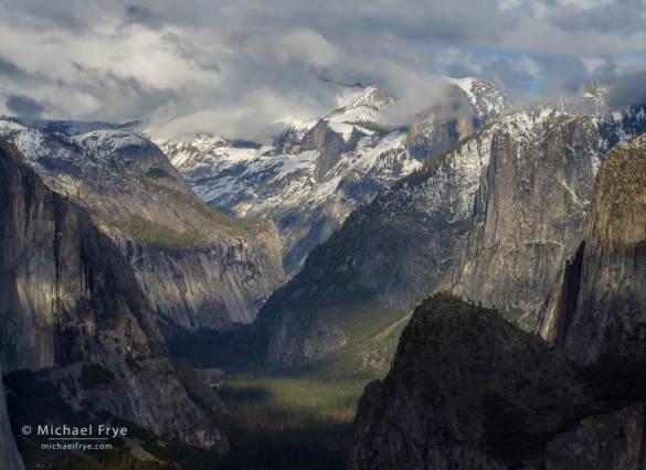
Dappled light on Half Dome and Yosemite Valley from near Old Inspiration Point, Saturday afternoon
Two storms unfolded almost exactly as forecasters predicted last week. On Wednesday night the first system dropped about 1.5 inches of rain on Yosemite Valley. The second storm on Friday dumped almost exactly two inches of rain. Badger Pass, 3,000 feet higher than the Valley, got about 18 inches of snow overall.
Despite these storms, rainfall totals are still only about 50% of average. In a normal year, Yosemite Valley would have received 26.9 inches of rain since last July 1st, however the current rainfall total for the season is only 12.9 inches.
(more…)
by Michael Frye | Feb 11, 2014 | Yosemite Photo Conditions
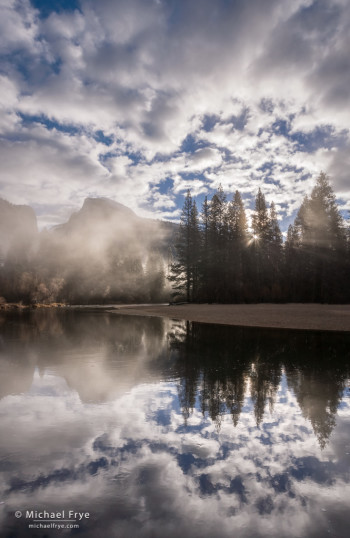
Misty sunrise, Half Dome, Merced River, and clouds, from yesterday morning
Northern California received some desperately-needed rain over the weekend. Most of that rain fell further north, so while Yosemite Valley got around 2.6 inches of rain, Blue Canyon, along Interstate 80 west of Lake Tahoe, got over 9 inches. But I’m not complaining. I’ll take whatever we can get, and those areas further north need the rain just as much as we do.
Like the last storm, this one also had a good sense of timing, clearing just before sunrise Monday morning. I rose early and photographed at several locations in Yosemite Valley, but my favorite image was this one of Half Dome from along the Merced River. I’ve posted other sunrise images from this spot before, but the cloud formations above Half Dome yesterday were exceptional.
The snow levels with this system were high, above 8,000 feet most of the time. I haven’t been able to find snow totals for Tuolumne Meadows, but Mammoth Mountain got two to three feet of snow, and Tuolumne probably got similar amounts.
The waterfalls in Yosemite Valley got a big boost from this storm. Their flow will diminish as the immediate runoff from the storm dissipates, but that new high-elevation snowpack will help feed the waterfalls for awhile, and we should see near-normal water flow for at least the next month or so.
(more…)
by Michael Frye | Feb 6, 2014 | Vision and Creativity
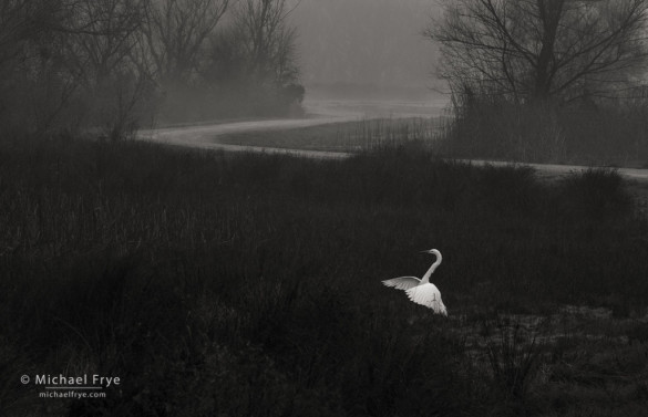
Great egret landing, San Joaquin Valley, CA, USA
This image was a lucky accident. I was standing next to my car along a tour route at one the wildlife refuges in the Central Valley, looking at a large flock of sandhill cranes and Ross’s geese, when I saw this egret flying by. I quickly turned, pressed the autofocus button on the back of the camera, followed the bird, and held the shutter button down as the egret landed.
The photograph languished in my archives for awhile before I processed it. Maybe I didn’t realize its potential right away because it was such a grab shot. But I did finally process it recently, and found several things to like about it.
First, there’s the contrast. Most of the frame is dark, but the two key elements – the bird and the road – are lighter, so they stand out. Any time you can place a light subject against a dark background, and have that subject stand out cleanly and distinctly against its surroundings, you have the potential for a strong image. There’s no sunlight in this photo, so the contrast isn’t created by sun and shade, but by the juxtaposition of a white bird against dark vegetation. But it doesn’t matter how the contrast is created, as long as it’s there. (The same idea also works for dark subjects against light backgrounds. I talk more about both kinds of contrast in this post.)
(more…)
by Michael Frye | Feb 4, 2014 | Yosemite Photo Conditions
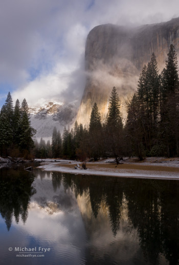
El Capitan and the Merced River during a clearing storm, Friday morning, Yosemite
A clearing storm in Yosemite Valley can be a memorable event, but not all clearing storms are equally photogenic. Some clear gradually, while others finish abruptly and spectacularly. Some storms clear at night, some in the middle of the day, but for photography you’d like the storm to clear just before sunrise or sunset.
Last Thursday, Yosemite Valley got two inches of rain, the first real precipitation in almost two months. Higher elevations got snow, and the temperature dropped enough to give the Valley a slight dusting at the tail end of the storm. The main part of the storm cleared around midday on Thursday – not the best time for photography, though still beautiful. But then showers resumed Thursday night, with the last of them moving through just before sunrise. Perfect timing.
My two brothers were visiting from Washington State, and the three of us rose early, drove up to Yosemite Valley, and headed for one of my favorite spots along the Merced River. The sun broke through the clouds and illuminated El Capitan briefly before the fog thickened and all the cliffs disappeared. But after about ten minutes El Cap re-emerged, the sun broke through, and we were treated to a classic Yosemite clearing storm. The first photograph here is probably my favorite from the morning, but I’ve posted a couple more images below, including a later image from Tunnel View – still a photogenic spot at 10:00 a.m.
(more…)


