In the Moment:
Michael Frye's Landscape Photography Blog
by Michael Frye | Jan 31, 2016 | Light and Weather, Yosemite Photo Conditions
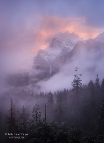
Misty sunset over Bridalveil Fall, Yosemite NP, CA, USA
Two weather systems have brought over two inches of precipitation to Yosemite Valley since Friday night. It was very warm at the beginning, with snow levels at 9,000 feet, but now the temperature has dropped, and it’s starting to snow.
I can even see flakes falling outside my window in Mariposa, at 2,800 feet, but it’s a little too warm for the snow to stick.
It looks like the storm might clear this afternoon, but these things are always hard to predict. Radar images show the tail end of the precipitation approaching, but that can be deceiving, as showers often linger over the mountains longer than you would otherwise expect. I’ll be keeping a close eye on things this afternoon, especially since there’s no precipitation in the seven-day forecast, so this might be the last chance to photograph a clearing storm for awhile. We’ll see what happens!
In the meantime, here’s a photograph from a clearing storm back in January of 2012. Chances are low that this current storm will bring an opportunity like this, but you can always hope.
— Michael Frye
(more…)
by Michael Frye | Jan 26, 2016 | Light and Weather
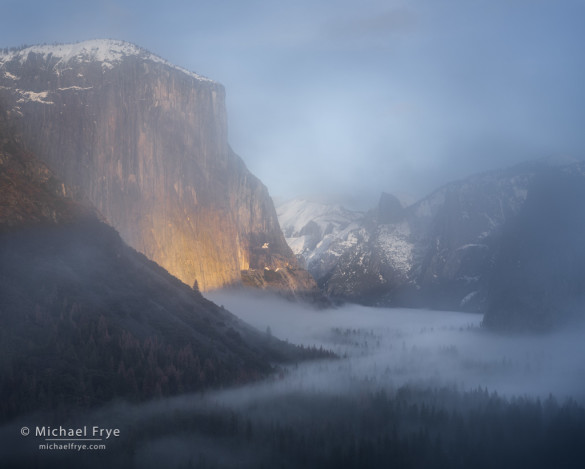
Yosemite Valley through the mist from Tunnel View, Yosemite, last Tuesday afternoon
We had a great time during our workshop last week in Yosemite, with a wonderful group of people, and some interesting weather. Although we didn’t get any new snow, we were able to photograph two clearing storms, plus two moonrises, and some misty trees. I’ve included a few of my favorite images from the week here.
We’ve had sunshine the last few days, and the fair weather is expected to continue until Friday, when another storm is predicted. The National Weather Service is expressing uncertainty about the strength and timing of this upcoming system. It should start off with high snow levels, which means rain in Yosemite Valley, but then the temperatures might drop enough toward the end of the storm to bring some snow down to the valley. We’ll see. But either way, more precipitation is good news in this state.
(more…)
by Michael Frye | Jan 20, 2016 | Yosemite Photo Conditions
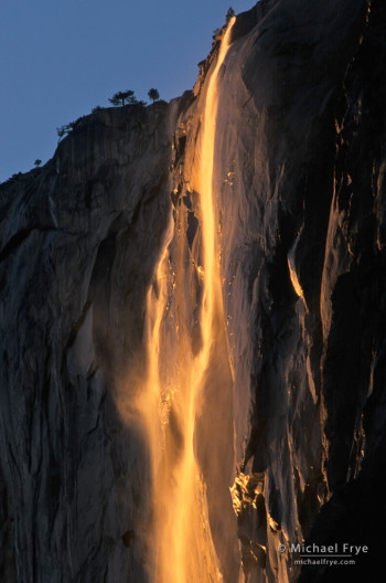
Horsetail Fall at sunset, Yosemite
We’re getting close to Horsetail Fall season, and I’m getting lots of questions about the water flow and the right time of year to photograph it.
As I said in my last post, there’s a healthy snowpack at higher elevations of Yosemite. Badger Pass ski area still reports 60 inches of snow on the ground at the base of the mountain (7,200 feet), and 72 inches at the top (8,000 feet). Horsetail’s small drainage on top of El Capitan lies at similar elevations, but faces south, and the slopes of Badger Pass face north. That means Horsetail’s drainage gets more sun, and the snow melts faster. But there should still be at least three or four feet of snow on top of El Cap right now, and it’s hard to imagine how all of that could melt between now and the third week of February. After four years of drought, it looks like we’ll finally have a good flow in Horsetail Fall at the right time of year.
But water flow is just one element. You also need the sun to set at the right angle to backlight Horsetail and make it turn orange, yet have the cliff behind it in the shade, so that the glowing, backlit, orange water is set against a dark background. My best estimate is that this happens between February 16th and 23rd, and perhaps even a few days beyond. (I delve into more detail about all that here.)
(more…)
by Michael Frye | Jan 17, 2016 | Light and Weather, Travels and Stories
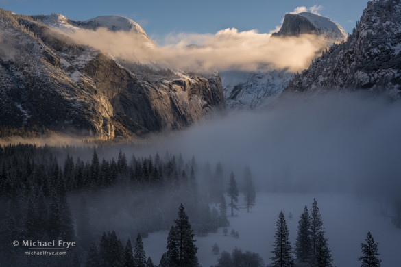
Half Dome and North Dome above Yosemite Valley, Friday morning, 8:24 a.m.
I’m so grateful for all the rain and snow we’ve been getting. After four years of drought, it’s wonderful to have a normal, wet winter. We’ve had storm after storm, and although most of the recent ones have been small, they add up. Yosemite Valley has received 24.63 inches of rain since July 1st, which is well above average. Badger Pass, at 7,200 feet, has 60 inches of snow on the ground, and the deepening snowpack raises hopes of full waterfalls this spring.
All this weather has been great for photography. It seems like we’ve already had more snow and clearing storms this season than the last four winters combined.
The latest in the series of small storms came through on Thursday night. I didn’t pay much attention to it, because it was predicted to be a weak system, and a warm one. I happened to wake up at about 4:00 a.m. Friday morning, and checked the radar images on my phone. It was raining pretty hard at our house, but the radar showed that the precipitation might end soon, possibly right around sunrise.
(more…)
by Michael Frye | Jan 10, 2016 | Advanced Techniques, Light and Weather
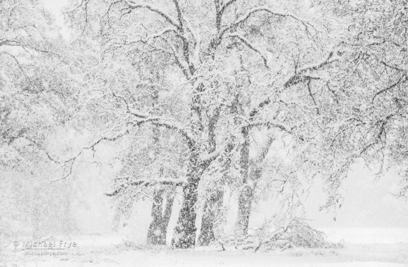
Snowy oaks, Yosemite. 1/125th of a second at f/11, 800 ISO, 150mm.
On Wednesday Claudia and I were in Yosemite Valley during a snowstorm. At times the snow was heavy, and wet, with big, fat flakes falling. It’s difficult to keep the camera dry and prevent water drops from getting on the lens under those conditions, but if you can manage that stuff you can find some beautiful scenes. The falling snow thickens the atmosphere, creating a fog-like effect, and the falling flakes themselves add to the snowy mood.
When it’s raining or snowing a lens hood is essential to keep water drops off the front glass. You also need to constantly check the front of the lens to make sure it’s clean, because it’s hard to see the drops through the viewfinder, but they become glaringly obvious later when looking at the images on a big screen, and are often impossible to clone out or otherwise fix. Telephoto lenses have longer hoods, which are better for keeping the front glass dry; all the photos here except one were made with my 70-200mm zoom.
(more…)


